This July, the MACMA team put our backpacks on and went to explore some landscapes, towns and rivers of the Marina Alta. An itinerary that combines the landscapes with the culture, heritage and gastronomy of our region. As the experience progresses, we will reveal the history and curiosities of the Gorgos River, the towns and landscapes that we have visited on this excursion, we hope you enjoy it a lot.

A LITTLE HISTORY. We know where we come from to decide where we are going.
The Gorgos River, also known as the Xaló River, is a river in the southeast of the Iberian Peninsula that flows through the northeast of the province of Alicante.
Like any river, its course has conditioned the settlement of human groups, crops, communications, toponymy and traditions. And in our region very especially, since we have been a border area, a land of Moors and Christians, of pirates, of farmers and ranchers, of stories and legends of which the river has been the protagonist and witness.
The Xaló/Gorgos River is, therefore, one of the transversal axes of the Marina Alta region, crossing it from Castell de Castells to Xàbia. It is not for nothing that the river basin has been populated from prehistoric times to the present day, since the ravines and rivers functioned as routes of communication.
Not all the towns where the Gorgos River flows live facing it, there are some that embrace it and make it their own, for example Xaló, a municipality located in the middle basin of the river. Here the river is the artery of the town and marks its life, the seasons and the rhythm of things, a differentiating element that the people of the town make their own to the point of changing the name of the river to Riu Xaló at the height of their term.
On the other hand, and curiously, the town of Gata de Gorgos, which takes its name from the river, is presented on the Gorgos river in a residual form, as it has developed mainly in the plain of the north bank, without representative roads that run along its banks or that end in it. Only the area of the bridge that crosses on the south bank and the church complex, the health center square and the library-museum, are presented as an urban environment in clear relation to the riverbed.
Despite everything, city councils are increasingly aware of the need for cities to turn to the river and the benefits that come with having the river once again be a living presence in their municipalities, and they are working hard to recover its use.
The river, which is undoubtedly a vital natural resource, has also been a cultural and recreational space for local communities throughout history. Today we are increasingly aware of the importance of its conservation and its potential as a space for leisure and unity between peoples.
However, the capacity for action of small town councils is limited, especially in infrastructure works or projects that, in addition, require the approval of several administrations.
A few geographical brushstrokes on the river
The Gorgos River rises at an altitude of 1,300 meters in the Serra d'Alfaro i Serrella, in the municipality of Fageca. Its course crosses the region of Marina Alta from west to east for approximately 53 km, crossing towns such as Vall de Pop, Xaló, Gata de Gorgos and finally flowing into the Mediterranean Sea between the capes of Sant Antoni and Sant Martí, in the municipality of Xàbia.
Its basin has an area of 283.2 km² and the river is about 50 km long. It begins its journey in the towns of Famorca and Castells de Serrella, where it is known as the Castells River. It passes through Benigembla, Murla, Parcent, Alcalalí, Xaló, etc. In the Pla de Petracos it receives the contribution of one of its most emblematic tributaries, the Malafí ravine, and is called the Xaló River while it crosses all the towns of the Vall de Pop and Aixa, but from Llíber it is called the Gorgos River. Then, it receives the waters of the Font d'Aixa ravine. It then passes through Gata de Gorgos and finally flows into Xàbia.
The rivers in this territory are called Rius-Rambla and we only see water on the surface during periods of heavy rain and cold drops.
A prominent feature of the Gorgos is the high permeability of its bed, which causes its flow to infiltrate easily, feeding numerous underground springs. This contributes to the fact that the river remains dry for much of the year, especially in summer, with the exception of some ponds that retain water throughout the year and are used for irrigation.
The flow of the Gorgos River varies according to the season. While in autumn or spring the rains cause a considerable increase in the amount of water, reaching overflowing, in summer it remains dry.
In some areas there are ponds that are maintained throughout the year and are used for irrigation. Also, thanks to the great permeability of their bed, several springs are nourished by underground filtration.
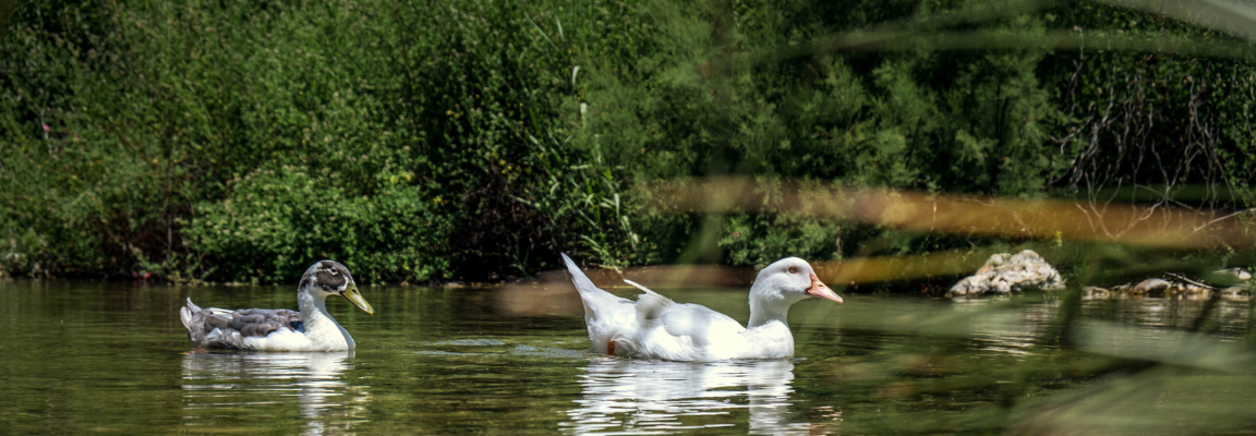
The endemic species of flora and fauna of the Marina Alta are present in the river, not only on the banks, but also in the vegetation of the bed and in general throughout the ecosystem around its course.
The most abundant plants are oleanders and reeds which are essential for local biodiversity, serving as habitats for several other species of flora and fauna.
Likewise, one of the most characteristic elements of riparian basins are the poplars. Riparian communities of poplars that mark the emergence of water, sometimes underground. In other words, when you observe an area of poplars in the landscape like the one in front of us, you will know that there is a river, a spring or a pond of water.
PROPOSED DAYS. Step by step we are making our way.
In order to follow the common thread that the course of the river provides us, we have prepared a route marked by some of the old watermills, which are aligned following the basin of the Xaló or Gorgos river, the main stream of the region.
In any case, in the route we propose today we do not want to focus on the technical or historical aspects of the mills, but rather to propose an itinerary that follows the course of the river and allows you to enjoy the landscape and nature from a more holistic perspective.
The mills guide our itinerary, but the route is much more and we want you to pay attention to everything around you: flowers, trees and plants, animals and birds, vestiges of past eras and present constructions.
Since the 18th century, water mills have replaced the old windmills, although they had the same purpose, grinding wheat, they used hydraulic energy. They also changed the blades for water wheels. The water reaches the mill through a ditch or directly from the splitter or weirs of the river. Next to the mills, ponds were built where water was stored both to move the grain and to soak it.
The mills we will visit today are in varying states of preservation, but they will serve as a guiding thread for a pleasant journey from the source of the Gorgos River to Xàbia, where it reaches the sea. They also give us an idea of the importance of the river for the economy of the interior of the region.
We will begin our route in Castell de Castells , where following the course of the river we will find the Molí de la Xancossa and the Molí de Gomis. The first is located to the left of the river, 400 meters from the town, it is the oldest in the region, dating from the 13th-14th centuries and received water from the Font de la Bota. All that remains is the wall of the mill and two vats of two and one meter in diameter respectively where the water was stored.
From the Xancossa mill, the water flowed through the Cerdà dam to the Gomis or Nou mill, also known as the Baix or Anouer mill. It is also located on the left side of the river and 1,300 meters from the town, its origin is much later, as it dates from 1731 and continued to be used until 1967.
First passing through the pretty town of Benigembla , head towards the town of Murla. Take the CV -719 and drive this route of about 3 km and six minutes that runs parallel to the river, which you will find on your right. Before reaching the town you can stop at the Bassa i Aqüeducte de la Vernissa, vestiges of a disappeared farmhouse, which together with Benigembla formed the two population centers of the medieval Muslim era.
Murla is located in the upper reaches of the Gorgos River and is a municipality that in the past had a mixed Christian-Muslim population, which is reflected in the structure of the town and in its current coat of arms.
Maybe it's time to grab a bite at one of their establishments. Normally, we like a savory breakfast, but in Murla you can't leave without having a coffee and some lemon rolls , a piece of lemon coca or ordering pa perdut , a dessert that can be eaten as breakfast and that will give you all the energy you need to continue the route.
Having had breakfast, it's time to set off! Leaving along the old road to Parcent, you will find the remains of a wall and the village pond, with an irregular shape. This is all that remains of the Molinet Vell, built in 1547 and which received water from the Font de la Vila and which was demolished in 1744.
We will now head to the town of Parcent , which is located in the middle course of the river, to look for the ruins of the Molí de Primo or Campoamor from the 17th-18th century, it had three wheels, two for wheat, and another lime and gypsum mill. It collected water from the Murla dam, about a thousand meters on the other side of the C-3318 road. It had two gypsum kilns and a lime kiln about four meters deep.
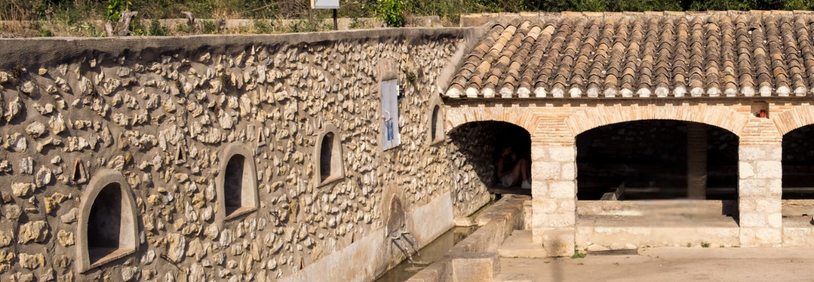
As we see throughout the region, the historical wealth is added to the water wealth of the territory, as demonstrated by the springs, washhouses, dams and, of course, the mills that we use as the guiding thread of our journey along the Gorgos River and its landscapes.
The next stop will take you to Alcalalí and its Molí de les Hortes, much older than the previous ones, as it dates from the 13th-11th centuries. It is in a very dilapidated state, and only the pond and a vat are preserved. Since you are in Alcalalí , you can visit the Medieval Tower or the Ethnological Museum.
When you finish your visit to Alcalalí, take the route that takes you to Xaló and look for the dam that brings water to the Molí de la Raconà, also from the 13th century and one of the best preserved in the entire region, with a pond and a vat in perfect condition.
Once you arrive in Xaló you will find the remains of the Molí de la Tarafa, which was partially destroyed at the end of the civil war. This mill was different from the others because of its vertical wheel, which turned it into a kind of watermill. The water was retained in the adjacent dam and from there it went to the Molí Nou, built in the 18th century also in Xaló and which is now a restaurant.
As we have explained before, we could say that Xaló lives by the river and the Gorgos River has had a crucial importance in its development. Therefore, apart from the two mills mentioned, we find the remains of another one inside the town, this third mill dates from the 14th-15th centuries and is intact, although it should be visited with caution because it could sink. It is curious to see how the water was led to a pond crossed by rails for the transport of grain.
The course of the river and history continues in the municipality of Lliber . Here we can find the remains of two mills, the Molinet de Lliber, practically in ruins, and the Molí del Xaraca, located at the exit of the town and which received water from the previous one. In addition to mills, in Llíber it is worth mentioning its wells , closely linked to agricultural activity, which collect water from various underground streams and carry it to the Gorgos.
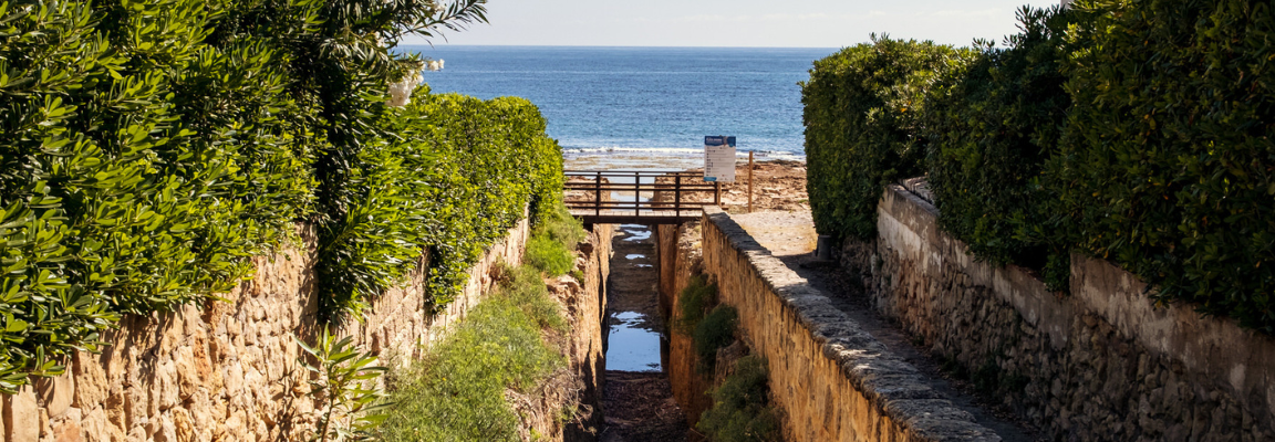
We will take the car and drive along the CV-748 road until we reach Gata de Gorgos, head towards Carrer Penyó, from where you can start a peaceful walk along the Gorgos river promenade. The path is short and pleasant, surrounded by nature and ideal for walking.
During the walk you will be able to observe the typical riverside vegetation and some ponds or areas with currents, especially if it has rained recently. There are benches and places to rest if you need to. This part of the route takes approximately one hour, between going and returning, if you do it at a leisurely pace.
When you're done, head back to the town center and visit the church of Sant Miquel Arcàngel, located in the heart of the historic center. Then, you can stroll through the old quarter, where you'll find some traditional taverns and shops selling local crafts, such as basketry, hats, and ceramics.
We have now reached the last town on our journey along the Gorgos River. It is Xàbia , where the river flows into the sea and joins its cold waters, which rise from the rugged mountains, with those of the Mediterranean Sea that bathes the coasts of the region, as a metaphor for what the Marina Alta is, its history and the particular character of its people.
We know that Xàbia once had at least four mills. Of the Caselles and Climent mills, located respectively on the left and right slopes of the Barranquera ravine, no remains remain today.
In contrast, the Narret Mill, located to the right of the Barranquera, can still be seen today as a ditch and a cistern, and the Garçó Mill, renovated as a chalet and which retains the canalization. In any case, although they are no longer preserved, knowing about their existence gives us an idea of the importance of the mills for the urban and economic development of the towns.
The Riu Gorgos ends in the Duanes de la Mar neighborhood, integrating with the beach and the coastline, with the Cap de Sant Antoni to the north, the Montgó to the northwest and the Granadella and Cap de la Nau mountains to the south. This is the end of our proposal and the time to stop and enjoy the views while eating some of the typical dishes such as octopus with penca, red suquet, fish cruet or rice with rice. All washed down with a white wine from the Marina Alta and a mistela from Xaló.
We recommend that you take advantage of this experience and this route to talk to the elderly people of the towns you visit. They are the living memory of the towns and will tell you exactly where the mills you are looking for were located and which, depending on their state of conservation, may have gone unnoticed. They can also give you details and tell you stories that we would hardly know without your testimony.
Not everything is on Google, not everything can be explained to us by artificial intelligence... Take advantage of this opportunity to learn from our elders about the uses and customs of the peoples, especially those related to the river, and become a guardian of the memory of the territory.
As you can see, the possibilities in our region are endless and in addition to our recommendations there are plenty of other activities and points of interest that you will discover for yourself, creating your own itinerary and your own experience. We invite you to share them with your friends, acquaintances and family and why not, with us.
*This experience is designed to be done in two days, either consecutively or on two different days. The MACMA team proposes routes, spaces and buildings to visit, but each person can adapt the experience to their abilities, physical resistance and interests. If you want more information or elements to visit in each town, you can enter the website of Descobrim la Marina Alta and adapt the experience to your tastes with the backpack.

AND MORE. On the table and in bed at the first cry.
 Where to buy |  where to eat |
 where to sleep |  Activities and others |